Thursday, February 28, 2013

Postcards (1900-1970)

 This is the Mall, in Waterford City, circa 1900.

 This rather nondescript postcard of The Diamond in Donegal Town dates from the 1960s.

 Dublin's Fair City circa 1970.

 Skibereen, Co. Cork, circa 1960s.

St. Patrick's Street in Cork City, circa late 1800s.


William Street in Galway City, circa 1930s/40s.
 Patrick Street, Kilkenny City, circa 1900.

Wednesday, February 27, 2013

A history tour of Swords (1921)

These passages were published as part of the wonderful The neighbourhood of Dublin: its topography, antiquities and historical associations by Weston St. John Joyce originally published in 1912 but this updated edition was published in 1921. You can download the whole book in .pdf here, beware though it's a big file. The book describes many areas of Dublin at the time and their histories. I've no doubt I'll dip into it again for posts. The reason I picked the Swords section is because it's my hometown and current place of residence and I have some nice roughly contemporary photos of the town to complement Joyce's written passages


Passing through Drumcondra, Santry, and Cloghran, we enter the ancient town of Swords, consisting of a long, wide street, situated on the great northern road, at a distance of eight miles from the metropolis. It derives its name from the Celtic word, sord, meaning pure, originally applied to St. Columbkille's well, which from time immerorial has been one of the principal sources of water supply in the town. This well is on the by-road to the left as we enter the village, but is now concealed from view, a pump having been erected over it during the past few years to preserve it from contamination.

One of the most notable events in the history of Swords is the funeral of King Brian Boru and his son Morrough, after the Battle of Clontarf, when the bodies of these warriors were conveyed in solemn procession from Dublin, and deposited for the night in the ancient monastery here, on the way to their final destination in Armagh.


According to the ancient records, Swords was burnt by the Danes in 1012, 1016, 1130, 1138, 1150, and 1166AD; and in 1185 it was taken and sacked by O'Melaghlin, King Of Meath. It must, consequently, have been a much more lively place of residence in those days than at the present time.

In 1578 a Royal mandate was issued for the better establishment of the Corporation of Swords, and for the purpose of determining the limits of its franchises and liberties. Commissioners were thereupon appointed to fix the boundaries, two miles on every side from the town.


At the commencement of the Insurrection of 1641, the Irish army assembled at Swords, and refusing to disperse in obedience to a warrant of the Lords Justices, Sir Charles Coote, with a considerable force, was sent out from Dublin to attack them. He found the entrance to the town on the Dublin side strongly barricaded, but succeeded in driving the insurgents from their positions after a sharp engagement with loss on both sides.

In 1788 Richard Talbot, of Malahide, obtained an Act of Parliament authorising him to construct a canal from Malahide to the Broadmeadow Water through Swords for the conveyance of goods, in consequence of the prohibitive charges for carriage by land, but the project was abandoned owing to the death of its originator.

Swords was constituted a borough by James I, returning two members to the Irish House of Commons, and was one of the few free boroughs in Ireland (ie, not private property), the franchise having been vested in what were called, in the slang of the period, "Potwallopers", meaning Protestants who had been resident for a continuous period of six months. The last two members were Francis Synge and Colonel Marcus Beresford.


The most conspicuous objects in the town are the round tower, 75 feet high, which is the only surviving portion of the original monastic establishment, and the mediaeval church tower, 68 feet high, belong to a structure which was erected not later than the 14th century. The round tower is surmounted by a cross, placed there about 100 years ago. The adjoining modern church was built in the early part of the last century out of the remains of the ancient one, an illustration of which latter appears in Grose's Antiquities.

And the northern end of the street stands the ancient episcopal palace or castle, designed as a defence against the Danes or other marauders, and sufficiently extensive to shelter the whole population of the town and their chattles within the circuit of its formidable walls. Admission to these ruins can be obtained on application at the adjoining house. The visitor is still shown the Constable's residence, the soldier's quarters,
and the Warder's walk, as also "St. Columbkille's Chapel," to the right of the entrance gate, with several watch towers one of which looking north, is in excellent preservation. A full description of the this in Alan's Liber Niger, and according to the inquisition recorded therein, it would appear that the place was in a ruinous condition so early as 1326.


A short distance north of the castle is an elevation known as Spital Hill, where, as the name indicates, there stood in ancient times a hospital, probably for lepers- an institution to be found in every town of importance during the period when that terrible scourge was prevalent in the country. In this connection, it should be mentioned that St. Finian, the Abbot of Swords, who was appointed by St. Columbkille in the 6th century, was himself a sufferer from this disease and is, in fact, usually referred to as "St. Finian the Leper." The ecclesiastical establishment here was founded about 550AD by St. Columbkille, who soon afterwards retired in exile to Iona, off the west coast of Scotland.

A mile and a quarter to the north-west of Swords are the ruins of Glasmore Abbey, an ancient ecclesiastical establishment which was destroyed in the 7th century by the Danes who murdered the entire community. Adjoining the ruins is St. Cronan's Well, named after the saint who fell in the massacre.

Leaving Swords by the main road, we presently cross the Broadmeadow Water, from the bridge over which is obtained a view along the estuary of that river towards Malahide. The road now passes through a dense wood- very dark in the night time- and we ascent the height beyond Turvey bridge, to the north may be seen Baldongan castle and the low hills of Naul and Garristown, while to the south are the dim forms of the Dublin mountains in the blue profile. We next pass the road to Skerries branching off to the right, and continuing along the main road, in about a quarter of a mile we reach Corduff Bridge, where we turn to the left along the road to Ballyboghil, meeting in about a mile and a half, a grass-grown lane on the left, leading up to the site of Grace Dieu, the once-famed convent of the Canonesses of St. Augustine.

Sunday, February 24, 2013

Mary Magdalene's Asylum (early 1900s and Streetview)

I was doing my usual browsing through old photographs online when I found this one that caught my eye. It's of Saint Mary Magdalen's Asylum sometime in the early 1900s. This was situated on Brookvale Road in Donnybrook in Dublin and as far as I can ascertain operated into the 1990s as a Magadalene Laundry. It's estimated that between 10,000 and 30,000 women were incarcerated in these institutions for "crimes" such as prostitution, having children out of wedlock, being intellectually disabled, or having been a victim of abuse. Only in the past week has an official apology been made by the Taoiseach, Enda Kenny, on behalf of the state, to survivors of these vile institutions. Thankfully the laundries no longer operate due to changing societal mores and economics. Frances Finnegan, an academic whose Do Penance or Perish: Magdalen Asylums in Ireland remains the most extensive study yet done on the laundries has said that "Possibly the advent of the washing machine has been as instrumental in closing these laundries as have changing attitudes." Below is the same location on Google's Streetview in recent years.


Thursday, February 21, 2013

The Bona-Fide Traveller (1905)

This humorous article was published in The Lepracaun in November 1905. I'm mainly posting it for the cartoon attached which I find hilarious, showing the journey from Finglas to Phibsboro at the time for a certain type of hardy wanderer. Thanks to the glacially paced reform of our licencing laws the bona-fide traveller no longer exists. Here's a description I found elsewhere that is succinct. "The BFT in need of refreshment had of course to be Bona Fide. He had to be on a journey to somewhere for a genuine reason and the journey had to be more than three miles long. He was not to be just looking for drink when he was not entitled to it. The premises were not to be opened in the ordinary way. The BFT had to seek admission and if the licensee was satisfied that he was in fact Bona Fide he could be admitted and served." This is from: http://www.rossespointshanty.com/Shanty%202011/Heritage/bonafide.htm

 Our Unnatural History - The Bona-Fide Traveller

The Bona-Fide Traveller is an animal which subsists chiefly on damp, which it travels long
distances to obtain. It is frequently found in the suburbs on Sundays before two and after
seven o'clock, when it goes in pursuit of its favourite moisture.
It is said that the first bona-fide traveller was manufactured by an Act of Parliament by way of
a legislative joke, which descriobed him as a person who had travelled at least three miles
from where he had slept the previous night, and whose visit to licenced premises, "must not be
for the prupose of obtaining drink." This exquisite sample of parliamentary humour has been
the wonder and delight of all who have come in contact with it- from the perplexed
"man on the door", who enquires from Macaulay's New Zealander if he slept there last night, to
his lordship of Appeal- that, forlorn hope to whom the nonplussed trader looks in vain, generally,
for an explaination of this lawyer's El Dorado.That genial combination of Socrates and Grimaldi,
the late Baron Dowse, defined the "traveller" as a person "who had a bona-fide thirst,
wanted a bona-fide drink, and had the the bona-fide money to pay for it."
The late Doctor Whyte, when City Coroner, described this animal as a "bona-fide nuisnace."
Mr. T.W. Ruseell, from his recent remakrs, evidently regards him as a combination of the seven
deadly sins with a dash of bubonic plague thrown in.
All if which birngs us no nearer to the solution of a question which will continue to fill
and to emplty pockets as long as desicated humanity can get beyond the "three mile limit" to
warble "here's fortune."
The language of this animal is largely composed of adjectives, sometimes of a highly suphureous
character, and at others of such an insanitary description as to bring tears to the eyes of
 the Public Health Committee.
Occasionally the "still small voice" of "Ten shillings or seven days," has the effect of restoring
the equilibrium, and it is whispered that the music of "Forty Shillings or a month" has invaribaly been the means of effecting a complete pacification.

Wednesday, February 20, 2013

Hall's Barn (1795-2011)

Hall's Barn is an unusual looking structure in Rathfarnham. Francis Jukes the 1795 painter of the first picture stated: "This is a very curious building, the singularity of which much attracted my notice. The stairs, by which you ascend it, are on the outside; and having a parapet wall, the ascent is rendered easy and safe. At the top the prospect is very beautiful, commanding a view of Lord Ely’s and Mt Palliser’s park’s and of the country, as far as the mountains. It is two and a half miles from Dublin".
It was built in 1772 or 1743 and here it is throughout the ages. It's of a similar style to and seemingly inspired directly by the Wonderful Barn. The first image is Jukes' painting from 1795, the second image is from 1900 and the final image is a more recent photograph. From googling it seems that parts of it at least were a dwelling place at one time.


That last and most recent image comes from: http://irelandinruins.blogspot.ie/2011/06/bottle-tower-co-dublin.html

Dublin Oil Gas Station (1824 and Streetview)

Here's the Dublin Oil Gas Station on Pearse Street drawn in 1824 by John Connolly. Below is the same building in recent years as viewed on Google's Streetview. I couldn't get the angle right. I'm hoping the next time I'm in that part of the world to take a better photo.


Tuesday, February 19, 2013

Fishermen Declare Merman Again Seen (1937)

Here's one that looks fit for the pages of the Fortean Times or The Codologist's Quarterly at the very least. It was printed in Adelaide's The Mail on Saturday, August 27, 1937.

The Connemara merman is reported to have reappeared. Two Irish fishermen declare that they saw him swimming. They gave him a mackerel, but later when he re-approached, fearing that their little boat might be upset, one of them hit him with an oar. Then the merman gave a whine and disappeared.

Thus is the cause of science damaged by the ignorant! Had the fishermen given the merman another mackerel instead of that crack with the oar they might have won his confidence and opened a new chapter in marine biology. An interesting feature of the case is that the merman reappeared in almost the same locality in which he was seen by two other fishermen last year. More over, the description of the various witnesses tally in important respects. The merman's first appearance — described in a special article in 'T'he Mail' of August 7 — was near the little village of Renvyle on the promontory north of Ballynakill Harbor, on the Connemara coast. Now he has been seen in the mouth of Ballynakill Bay itself. Thomas O'Toole and Michael Warde saw him. He came swimming toward their curragh, using the breast-stroke described by the previous witnesses, Regan and Heanue.

Thinking that he was coming aboard, O'Toole and Warde pulled away, outdistancing the merman, who, however, followed. When they stopped rowing, he came within a few yards of the boat, and Warde threw him a mackerel. He snatched it eagerly with both hands and disappeared. There was no sign of the fish when, a few minutes later, the merman reappeared alongside the curragh. Fearing that he would upset the boat, O'Toole then struck Myn with an oar. The merman moaned and vanished. The fishermen describe their visitor as having straw-like, shaggy hair, a beard, very red lips, and bushy eyebrows. His skin was fair in front but blue at the back. He swam with his head and shoulders above the surface. This tallies in the main with the description of the previous witnesses- who, however, added that the merman wore a blue petticoat like a woman's apron.

Saturday, February 16, 2013

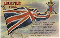
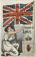
Anti-Home Rule Postcards (1912-1914) #2


Here's even more Anti-Home Rule postcards from the same era. Of these my favourites are the map one and the one of the belligerent wee cub from Belfast. The map card displays the "Gulf Of Socialism" which would fit in comfortably in the anti-Obama rhetoric in America in recent years. This set also includes Donegall Place under Home Rule, a companion to the Belfast and Carrickfergus postcards in the previous post. There's also the Ulster Scot aptly proclaiming his opposition to Home Rule in Ulster Scots.

Anti-Home Rule Postcards (1912-1914) #1


This is a selection of postcards created by Belfast printers to capitalise on and promote the anti-Home Rule fervour that caught on in much of what is now Northern Ireland directly after the introduction of the Third Home Rule Bill by the British Parliament in 1912. While the Bill was passed by the House Of Commons, the House Of Lords repeatedly blocked it and by the time the Lords was overruled the Great War had made the legislation moot. Some of the postcards clearly come out against any measure of Home Rule but many of them espouse the continued political union between the province of Ulster and Britain (England then often used interchangeably with the term). At least one of the postcards features the partition of Ireland including the whole of Ulster, which of course was not to be. The postcards vary from the humorous to the pompous, from lovely draughtsmanship to amateurish scrawls. My favourites include the rather kitsch No Home Rule one with the male personifications of each country of the United Kingdom, and Belfast and Carrickfergus under Home Rule. Another notable one is the Home Rule Parliament, College Green, 1915 one which includes a distinctly 19th century portrayal of bellicose Irish Catholics. Although political postcards of this type don't really exist anymore much of the same iconography used in these postcards can be seen today in murals in Unionist/Loyalist areas all throughout Northern Ireland. Indeed, a minor industry has sprung up around bringing tourists to view political murals from both communities in Belfast and elsewhere, but more on that in another post.